Success Stories
In-depth insights from our successful projects and the measurable impact we've delivered for our clients
Digital Twin Platform
Experience the future of offshore asset management with our digital twin development services. The Virtual Eye platform eliminates frequent site visits through real-time visual surveillance and AI-powered analytics, enabling complete situational awareness without physical presence.
Digital Twin Platform Development
Virtual Eye: Creating a Unified Digital Reality for Offshore Asset Management
1. Challenge
Asset-intensive industries often operate with fragmented data—from legacy drawings and isolated control systems to disparate ERP modules. This lack of a single source of truth hinders decision-making, prolongs maintenance cycles, and forces personnel to undertake unnecessary and costly site visits. A major energy operator needed a unified platform to visualize, interrogate, and manage their offshore assets remotely, integrating real-time and historical data to enhance operational efficiency and safety.
Virtue Eye, 3D Laser Scanning, Data Integration.
2. Our Approach & Solution
The Geosoft Digital Twin department developed and deployed 'Virtual Eye', our proprietary digital twin platform. Our approach was to create a central nervous system for physical assets, moving beyond simple 3D visualization to an intelligent, data-rich environment.
- Platform Architecture: We built a scalable cloud-based platform leveraging microservices architecture, ensuring robust performance and easy integration with existing client systems.
- ERP & System Integration: Virtual Eye was seamlessly integrated with the client’s SAP system and other data sources, pulling in live tag information, maintenance histories, and work orders directly into the 3D model.
- AI & Computer Vision: We implemented machine learning algorithms to automate the recognition and registration of asset tag numbers from point cloud data, eliminating manual entry and ensuring data accuracy.
- User-Centric Design: The interface was designed for intuitive use, requiring minimal training. Critical information is contextualized within the 3D environment, putting asset data, documentation, and real-time metrics at the user’s fingertips.
3. Technologies & Methodologies
| Category | Tool / Technology | Purpose |
|---|---|---|
| Platform Development | In-House Proprietary Framework, Microsoft Azure | Scalable cloud infrastructure, secure data hosting |
| 3D Engine | Unity 3D, WebGL | High-fidelity visualization and browser-based access |
| Data Integration | SAP ERP, RESTful APIs, SQL Databases | Real-time connectivity to asset management and business systems |
| AI & Machine Learning | Python, TensorFlow, Computer Vision Libraries | Automated tag recognition, predictive analytics |
| Security & Access Control | Azure Active Directory | Role-based permissions and secure user authentication |
| Standards | ISO 27001, ISO 19650 | Data security, information management |
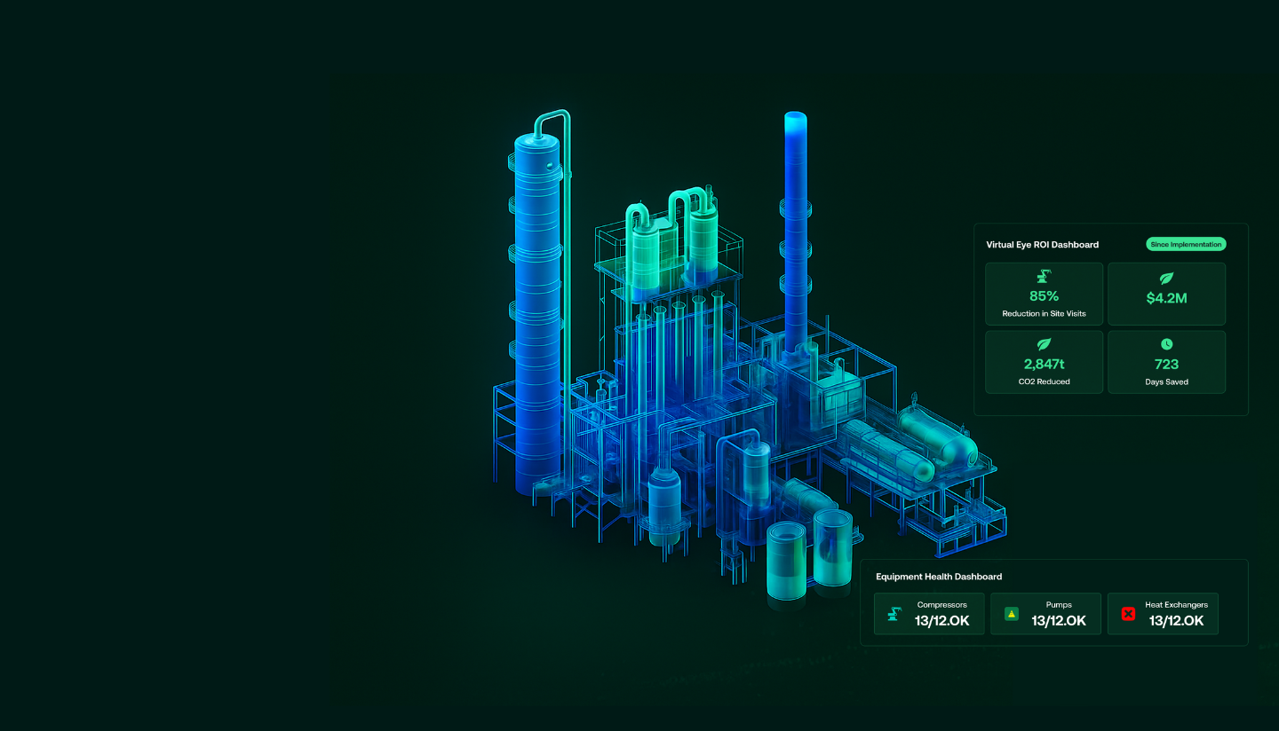
4. Results & Impact
- Operational Efficiency: Reduced the time for asset data retrieval and validation by 90%, enabling faster and more informed decision-making.
- Cost & Safety: Eliminated the need for frequent physical site visits for data verification and planning, resulting in significant travel cost savings and enhanced personnel safety.
- Data Integrity: Achieved 100% integration between the 3D model and the client’s SAP ERP, creating a single, reliable source of truth for the asset lifecycle.
- Future-Proofing: Established a scalable digital backbone that supports future expansion, including IoT sensor integration and predictive maintenance modules, maximizing the asset’s long-term value.
Conclusion
This project demonstrates Geosoft's capability to deliver not just a model, but a mission-critical operational platform. By fusing precise 3D visualization with deep enterprise data integration and AI, we provided a clear, actionable view of complex assets. The Virtual Eye platform empowers our client to move from reactive maintenance to predictive, data-driven operations, setting a new benchmark for digital asset management in the energy sector.
Trusted by Industry Leaders
We partner with offshore operators and pipeline companies to deliver precision survey solutions.

Offshore Operations
Major offshore oil and gas operators trust our survey technology for critical infrastructure projects.

Pipeline Companies
Leading pipeline infrastructure companies rely on our precision mapping and underground utility services.

Engineering Firms
Engineering consultancies partner with us for accurate survey data and 3D modeling services.
Impact

Timeline
Comprehensive survey results delivered in six weeks.

Deliverables
Topographical drawings, digital terrain models, contour maps, longitudinal profiles, 2D & 3D underground utility maps.

Safety
Avoided potential hazards and optimized pipeline route.

Cost-Efficiency
Achieved significant cost savings and reduced construction time.

Technology
Utilized advanced tools like LiDAR and GPR.

Efficiency
Enhanced data collection and analysis processes.
Let GeoSoft help you shape the future of your industry
Our advanced digital twin solutions redefine asset management, enhancing efficiency and collaboration.