Success Stories
In-depth insights from our successful projects and the measurable impact we've delivered for our clients
Logistic Route Optimization Survey
Transforming offshore plant logistics through advanced SLAM technology and 3D mapping. Our team's rapid route analysis identified optimal pathways for heavy equipment transport, reducing planning time from months to weeks.
Logistic Route Optimization Survey:
Enabling Efficient Heavy Equipment Transport in Complex Offshore Environments Navigating Complexity: How Advanced 3D Mapping Transformed Offshore Logistics Planning
1. Challenge
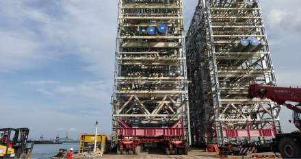
A major oil and gas contractor faced considerable challenges navigating the complex pathways of an offshore plant to transport heavy electrical substations to designated locations. The substantial weight of the equipment, coupled with the intricate layout of the plant, made timely mobilization exceptionally difficult. The contractor needed detailed insights into available routes, road conditions, potential obstructions, load-bearing capacity, spatial constraints, pinch points, and road curvatures. Traditionally, gathering this comprehensive information through manual surveys would require multiple offshore visits and take up to several months, jeopardizing project schedules and increasing costs significantly.
SLAM technology and 3D mapping
2. Our Approach & Solution
Our geospatial team implemented an advanced mobile mapping solution that rapidly captured and analyzed the entire plant's infrastructure to identify optimal transport routes.
- SLAM Technology Deployment: We utilized simultaneous localization and mapping (SLAM) technology to rapidly capture the offshore plant’s road network, creating a detailed 3D point cloud of the entire facility with centimeter-level accuracy.
- Comprehensive Spatial Analysis: The team conducted detailed analysis of the captured data, identifying all potential obstructions, clearance issues, weight restrictions, and spatial constraints that could impact the transport of heavy substations.
- Route Simulation & Optimization: Advanced processing and simulation techniques were applied to identify the most efficient routes, taking into account equipment dimensions, turning radii, and load distribution requirements.
- Multi-Disciplinary Collaboration: Worked closely with structural engineers, transport specialists, and operations teams to validate the identified routes and ensure all safety and operational requirements were met.
- Rapid Deliverable Generation: Produced comprehensive route maps, obstruction reports, and 3D visualizations within weeks rather than the months typically required for traditional survey methods.
3. Technologies & Methodologies
| Category | Tool / Technology | Purpose |
|---|---|---|
| Mobile Mapping | SLAM-based Mobile Scanner | Rapid 3D data capture of complex environments |
| Data Processing | Custom Point Cloud Software | Obstruction identification and clearance analysis |
| Route Analysis | AutoCAD Civil 3D, Navisworks | Spatial analysis and route optimization |
| Simulation Software | Specialized Transport Simulation | Equipment movement and turning radius validation |
| Deliverable Generation | ArcGIS, Adobe Creative Suite | Comprehensive reporting and visualization |
| Quality Assurance | Redundant Data Capture | Accuracy verification and completeness checking |
4. Results & Impact
- Dramatic Time Savings: Reduced the traditional planning timeline from several months to just weeks, enabling the project to proceed on an accelerated schedule.
- Comprehensive Obstruction Identification: Achieved 100% identification of all potential obstructions and constraints, allowing for proactive clearance and modification planning.
- Cost Avoidance: Prevented potential delays and re-routing costs estimated at $2.5M+ by identifying optimal routes upfront and avoiding unexpected obstacles during transport.
- Safety Enhancement: Eliminated the risks associated with manual surveys in live plant environments and ensured the transport route was thoroughly vetted for safety compliance.
- Operational Efficiency: Enabled the contractor to proceed with confidence, knowing that the identified routes were validated through advanced simulation and analysis.
Conclusion
This project demonstrates our team's ability to transform complex logistical challenges into streamlined, efficient operations through advanced geospatial technologies. By leveraging SLAM technology and sophisticated spatial analysis, we provided the clarity and confidence needed to move heavy equipment through one of the most complex environments imaginable. The successful route optimization doesn't just represent technical achievement—it demonstrates how modern surveying techniques can dramatically accelerate project timelines while enhancing safety and reducing costs. This capability to rapidly analyze and optimize complex spatial challenges forms a critical component of our approach to industrial logistics and infrastructure management.
Trusted by Industry Leaders
We partner with offshore operators and pipeline companies to deliver precision survey solutions.

Offshore Operations
Major offshore oil and gas operators trust our survey technology for critical infrastructure projects.

Pipeline Companies
Leading pipeline infrastructure companies rely on our precision mapping and underground utility services.

Engineering Firms
Engineering consultancies partner with us for accurate survey data and 3D modeling services.
Impact

Timeline
Comprehensive survey results delivered in six weeks.

Deliverables
Topographical drawings, digital terrain models, contour maps, longitudinal profiles, 2D & 3D underground utility maps.

Safety
Avoided potential hazards and optimized pipeline route.

Cost-Efficiency
Achieved significant cost savings and reduced construction time.

Technology
Utilized advanced tools like LiDAR and GPR.

Efficiency
Enhanced data collection and analysis processes.
Let GeoSoft help you shape the future of your industry
Our advanced digital twin solutions redefine asset management, enhancing efficiency and collaboration.