Pipeline Inspection

Subsea services

We deploy advanced geophysical tools and specialized sensors for comprehensive pipeline integrity monitoring, detecting corrosion, leaks, and structural deformation in critical underwater assets with battle-tested precision.

From Linear Assets to Continuous Integrity

Our pipeline inspection services integrate ROVs, intelligent crawlers, imaging sonar, high-resolution bathymetry, and a comprehensive suite of non-destructive testing (NDT) tools to reveal the full condition picture — coating breakdown and disbondment, free spans, upheaval and lateral buckling, seabed exposure, scour, and structural instability — identified, positioned, and recorded well before they threaten flow assurance, structural integrity, or regulatory compliance

What we deliver is not an inspection report — it is the foundation for smarter asset management. Our pipeline condition datasets directly feed risk-based inspection (RBI) frameworks, remaining-life and life-extension assessments, and targeted repair and intervention planning across oil and gas pipelines, water transmission mains, power and data cables, and the emerging subsea infrastructure backbone of the global energy transition. Where other teams find defects, we deliver the intelligence operators need to make confident, cost-efficient decisions about every pipeline they run — for the next inspection cycle and the decades beyond it.Shape

How We Inspect Pipelines

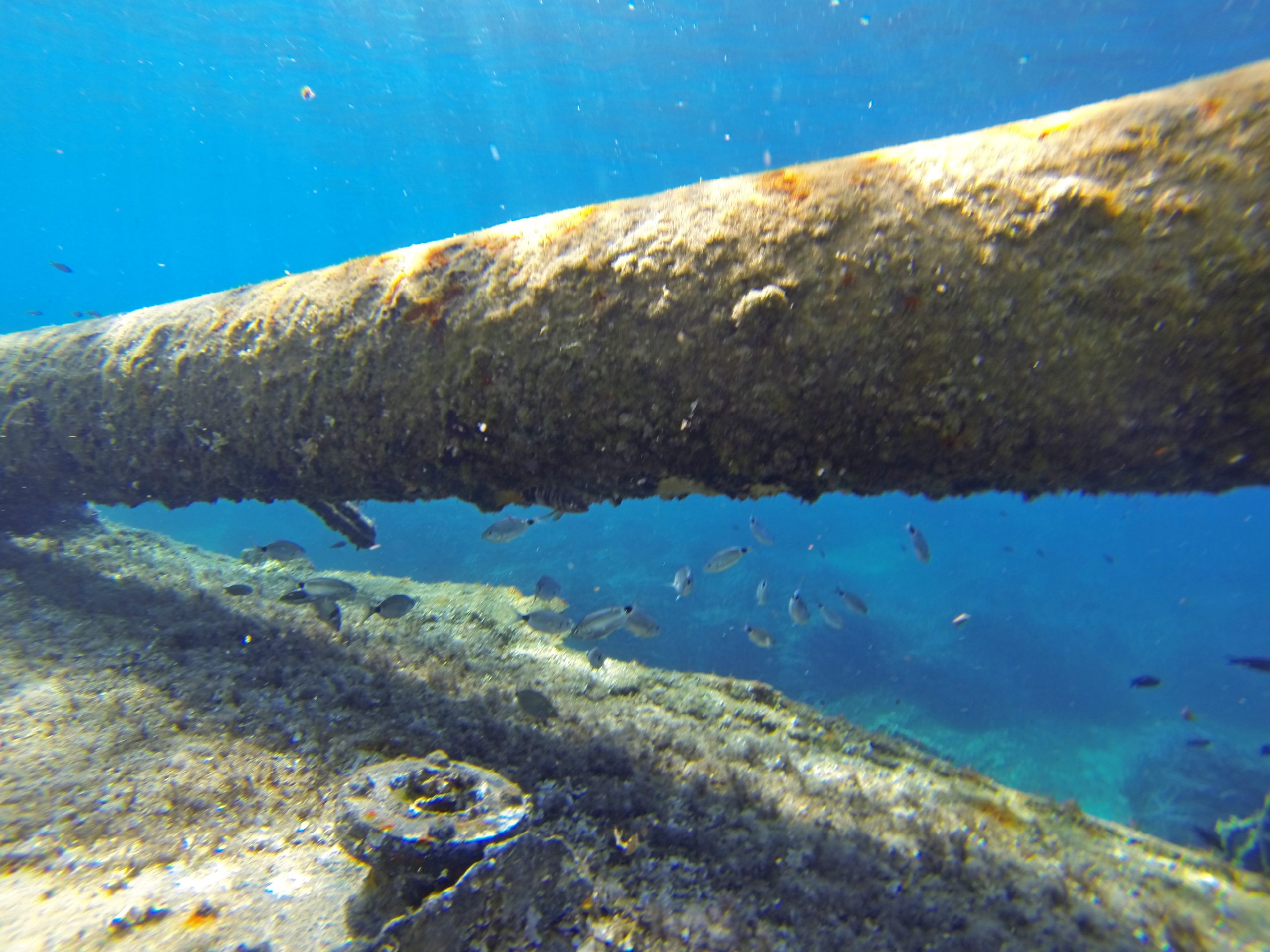
ROV Based GVI and CVI Runs

Inspection and work class ROVs fly controlled standoff above the line performing General Visual Inspection (GVI) for global condition and Close Visual Inspection (CVI) at areas of interest. High definition cameras, laser scaling, and imaging sonar capture coating state, anode condition, supports, crossings, and any physical damage or debris interacting with the pipeline.

Sonar & Bathymetry for Spans and Burial

Multibeam and profiling sonars, combined with highresolution bathymetry, map seabed morphology, trench geometry, and contact/support conditions along the pipeline route. These datasets quantify span heights and lengths, exposure, lateral displacement, and potential scour zones that affect structural response and onbottom stability.

Integrated NDT and Cathodic Protection

ROVmounted CP probes, UT/WT thickness gauges, and cleaning tools provide direct measurements of cathodic protection performance and wall loss at targeted locations. Readings are referenced to pipeline KP and geospatial coordinates so integrity engineers can correlate anomalies with coating damage, environment, and historical data.

Shore Approaches, Crossings & Internals

In shallow, congested or nearshore environments, specialised shallowwater ROVs or crawler systems are used to inspect shore approaches, river and road crossings, and jetties where hydrodynamic and thirdparty risks are highest. Internal inspection (ILI) data and external survey results are reconciled to validate wallloss features, confirm repairs, and close out integrity anomalies.

What We Deliver: Pipeline Integrity Intelligence

Continuous RouteCondition Records

A georeferenced condition log covering the full inspected length, documenting coating state, anodes, supports, exposure, crossings, clamps, and foreign objects in a structured database. This replaces isolated inspection snapshots with a continuous integrity baseline for each pipeline segment.

CP & WallThickness Measurement Packages

Processed CP profiles, potential readings, and UT/WT results at key locations, with trendable datasets that support lifeextension assessments and verification of CP retrofit performance. Results are delivered in engineering formats suitable for direct import into structural and corrosion models.

AsLaid / AsIs Comparison & Change Detection

Where previous surveys or aslaid data exist, current inspection results are compared to detect route migration, new spans, scour, burial loss, or progressive damage. Changedetection maps and KPbased summaries allow operators to focus resources on sections where conditions are evolving fastest.

GIS, BIM & DigitalTwin Ready Pipeline Data

All pipeline inspection outputs—tracks, spans, anomalies, measurements, imagery—are packaged as fully georeferenced layers for GIS, BIM, and digital twins. This ensures that integrity, operations, and engineering teams work from a single, consistent, spatially aware picture of pipeline health across the asset lifecycle.

Industries We Serve

industry image

deliver image

Oil, Gas & Renewables

Platform Site Surveys | Pipeline Route Surveys | Offshore Wind Foundation Zones | Cable Landing Corridors | Scour Monitoring | Free-Span Detection

industry  image

industry image

Ports & Harbours

Nautical Charting | Approach Channel Surveys | Berth Pocket Mapping | Turning Circle Verification | Under-Keel Clearance Analysis | Dredge Volume Computation

industry  image

deliver image

Coastal Engineering & Climate Resilience

Shoreline Change Mapping | Beach Profile Surveys | Nearshore Morphology | Storm Impact Assessment | Breakwater Design | Coastal Defence Monitoring

industry image

deliver image

Dredging & Marine Construction

Pre/Post-Dredge Surveys | Pay-Volume Certification | Rock Placement Verification | Construction Tolerance Checks | As-Built Documentation | Material Classification

industry  image

industry image

Marine Infrastructure

Bridge Pier Scour Assessment | Causeway Alignment Surveys | Submerged Asset Inspection | Intake/Outfall Mapping | Quay Wall Condition Assessment

industry  image

deliver image

Water Resources & Inland Hydraulics

Reservoir & Dam Surveys | River Cross-Sections | Floodplain Bathymetry | Sedimentation Studies | Hydrodynamic Model Inputs

industry image

deliver image

Marine Mining

Seabed Mineral Exploration | Deep‑Ocean Resource Mapping | AUV Survey | Multiphysics Targeting | Environmental Baseline

industry  image

industry image

Environmental Management

Benthic Habitat Mapping | Seagrass & Reef Extent | Sediment Dynamics | Dredge Plume Tracking | Marine Protected Area Baseline | Change Monitoring

industry  image

deliver image

Defence & Security

Seabed Clearance | UXO Pre-Characterization | Submerged Obstruction Detection | Underwater Infrastructure Mapping | Risk & Vulnerability Assessment

Our Methodology: Precision at Every Stage

A proven four-stage process ensuring accuracy, compliance, and actionable insights

deliver image

Plan with Intelligence

Before mobilizing, we begin with a data-driven understanding of your asset environment. We perform a comprehensive site intelligence review — analyzing existing drawings, access limitations, hazardous zones, operational constraints, and required accuracy levels.

deliver image

Precision Field Acquisition with real time QC

Our field teams deploy fully calibrated instruments in strict accordance with manufacturer specifications and project QA protocols. Intelligent workflows deliver real-time on-site feedback on coverage, registration integrity, and data quality

deliver image

AI-Driven Data Processing & Extraction

Curates raw data, Guides AI, Validates Output into actionable digital intelligence through a hybrid pipeline of advanced algorithms, machine learning models, and expert review.

deliver image

Decision-Ready Deliverables

Outputs are not merely models but enterprise-ready information assets. All datasets undergo independent quality assurance audits. We ensure your organization can immediately operationalize the data for planning, maintenance, and strategic decision-making.

Case Studies

We're building a greener tomorrow. Our solutions optimize operations, cut waste, and lower emissions, supporting net-zero goals.

Subsea services

Subsea Geophysical Services

Advanced nearshore pipeline mapping using integrated geophysical technologies to determine precise burial status and mitigate environmental risks. Our comprehensive survey delivers the critical data needed…

200m
Survey Corridor Width
100%
Data Compliance
Zero
Environmental Incidents
Subsea services

Precision Positioning & Metrology

Millimeter-accurate jacket positioning using robotic total stations and high-precision leveling to ensure perfect fit-up between new and existing structures. Our exacting survey methodology delivered flawless…

±2mm
Positioning Accurac
100%
Fit-Up Accuracy
Zero
Safety Incidents

Why Organizations Choose Our Pipeline Inspection Services

Technical Excellence

Industry-leading accuracy specifications (±1–2 mm TLS, ±2–5 cm aerial) backed by systematic, documented QA/QC processes ensuring reliable, repeatable results across diverse project types — from offshore platforms in extreme marine environments to sensitive heritage interiors.

Operational Efficiency

Multi-platform deployment and AI-accelerated processing compress project timelines by up to 70%. What once required months of manual survey and CAD drafting now delivers registered, classified point clouds and intelligent models in days to weeks.

Integrated Solutions

Complete service delivery from project planning and field acquisition through processing, modeling, and specialized analysis — all under one roof. No fragmented vendor chains, no data conversion losses, no accountability gaps.

Industry Expertise

25+ years of specialized knowledge across regulated, high-stakes environments. We don’t just capture geometry — we understand what it means for your operations, your compliance obligations, and your capital planning decisions.

Proven ROI

Our clients consistently document measurable returns: 30–50% reduction in field rework, 20–40% faster project delivery, elimination of fabrication mismatches, and extended asset service life through predictive condition monitoring. Reality capture isn’t an expense — it’s a multiplier on every downstream decision.

The Subsea Intelligence Advantage

At the intersection of marine survey rigour and advanced digital workflows, we transform raw acoustic and optical signals into validated, fully integrated subsea models that engineering, dredging, and operations teams can interrogate, trust, and act on from day one.

Contact Our Specialist

Get in touch to discuss comprehensive terrestrial and aerial laser scanning addressing your project requirements.


Global Operations
24/7 support across multiple time zones